Base History \ Arrival
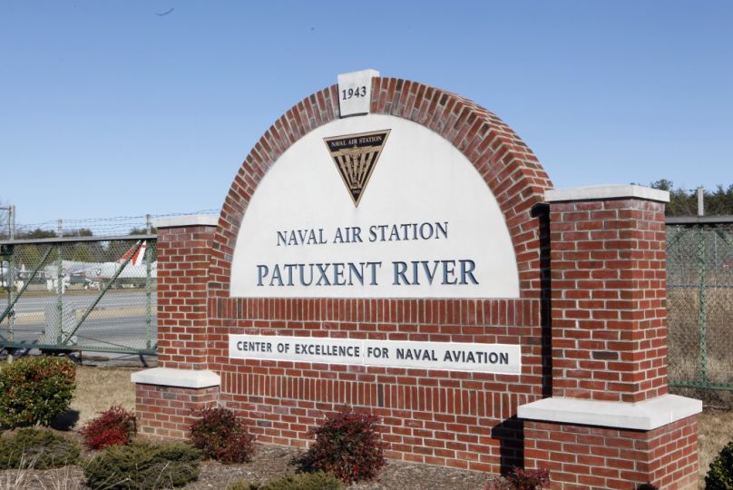
Naval Air Station Patuxent River stretches across approximately 12 miles of shoreline at the mouth of the Patuxent River, overlooking the picturesque Chesapeake Bay, 65 miles southeast of Washington, D.C. and 75 miles south of Baltimore. NAS Patuxent River covers more than 13,800 acres, including the Bloodsworth Island Range and the Webster Field Annex, which is located about 15 miles south of the station. Patuxent River is located in Southern Maryland, St Mary's County, the town outside the base gate is Lexington Park.
MISSION - Patuxent River is home to the Naval Air Systems Command and the Naval Air Warfare Center Aircraft Division headquarters. NAVAIR's Aircraft Division at Patuxent River (including the Webster Field Annex) is the Navy's full spectrum acquisition, research, development, test, evaluation and engineering and fleet support activity for manned and unmanned aircraft, engines, avionics, aircraft support systems and ship/shore/air operations.
NAS Patuxent River falls under the command of Naval District Washington. Naval District Washington is one of ten regions reporting to the shore installation management command, called Commander, Navy Installations. Headquartered at the Washington Navy Yard, Naval District Washington is the regional provider of common operating support to twenty Navy installations, including Naval Air Station Patuxent River, within a one hundred mile radius of the Pentagon. Naval District Washington is also known as the Quarterdeck of the Navy.
With more than 165,000 air operations annually, activities at Patuxent River fly 140 aircraft (type/model/series) over 780 restricted and 5,000 controlled square miles. The RDT&E capability ranges from concepts analysis and procurement to flight testing and support equipment. Patuxent River has five runways and 935 buildings with an estimated plant value of $2.0 billion.
POPULATION SERVED - The Navy has become the largest employer in the community. More than 20,000 people are employed on the station. This work force includes approximately 3,000 active-duty service members, 7,800 civil service employees, 9,000 defense contractor employees, and 400 non-appropriated-fund employees. In addition, the station services approximately 4,500 military family members.
In addition to bringing a larger work force to Southern Maryland, the station has expanded facilities in recent years. During the last two decades, the station has grown to include a manned flight simulator, a large aircraft anechoic chamber, the Capt. Steven A. Hazelrigg Flight Test Facility, the U.S. Naval Test Pilot School academic building and a pool facility at the Aviation Survival Training Center.
These new facilities have significantly improved aviation safety and the quality of naval aviation products. With the consolidated work force and expanded facilities, Naval Air Station Patuxent River is where the future of naval aviation begins.
Directions
Airports
There are no airports in the immediate vicinity of NAS Patuxent River. There are, however, 3 major airports in the Washington, DC Metro area. These are Dulles International (IAD) in Dulles,Virginia; Baltimore-Washington International (BWI); and Ronald Reagan National Airport (DCA) in Arlington, Va.
Driving Directions
Washington Dulles International (IAD)
Drive East on Saarinen Circle for 13.0 miles, then merge onto VA-267 E (Dulles Toll Rd) (toll required for some segments) for 0.9 miles. Take Exit 18 (I-495, Baltimore, Richmond) on the right, and drive for 29.2 miles. Take Exit 11A (MD-4 SOUTH/EAST, Pennsylvania Av, Upper Marlboro) on the right, and continue onto MD-4 S (Pennsylvania Av). Drive south on MD-4 for approximately 49.5 miles. Continue through Prince Frederick and over the Governor Thomas Johnson Bridge. Go to the traffic light at the intersection of Routes 4 and 235 and turn left onto Route 235. Gate 1 is on the left at the intersection of Route 235 and Pegg Road. Gate 2 is on the left at the intersection of Route 235 and Great Mills Road (Route 246). Both intersections have a stop light.
From Ronald Reagan National Airport (DCA)
Take Route 1 south to I-95 toward Baltimore. Go about 4 miles to Route 210 south toward Indian Head. Go 10 miles to Route 228 and turn left toward Waldorf. Go 6 miles, cross Route 301, and keep straight onto Route 5 south. Route 5 will become Route 235 as you continue straight. Continue on Route 235 to Lexington Park. Gate 1 is on the left at the intersection of Route 235 and Pegg Road. Gate 2 is on the left at the intersection of Route 235 and Great Mills Road (Route 246). Both intersections have a stop light.
From Baltimore/Washington International Airport (BWI)
Take I-97 south to Route 3 south. Route 3 will become Route 301 south. From 301 south exit to Route 4 south. Continue through Prince Frederick and over the Governor Thomas Johnson Bridge. Go to the traffic light at the intersection of Routes 4 and 235 and turn left onto Route 235. Gate 1 is on the left at the intersection of Route 235 and Pegg Road. Gate 2 is on the left at the intersection of Route 235 and Great Mills Road (Route 246). Both intersections have a stop light.
From Route 301 or I-95 (3 Options)
Route 234 South off of Route 301
Go about 20 miles to intersection of Route 5 south - make a right. Continue straight about 15 miles to Great Mills Road (Route 246, light) and turn left. Go approximately four miles and Gate 2 is at the end of Great Mills Road. For Gate 1 turn north on Route 235 and Gate 1 is on the right at the intersection of Pegg Road and Route 235.
Route 4 South from Route 301 or I-95
Go about 45 miles from Route 301 (8 miles further from I-95), across the Governor Thomas Johnson Bridge to Route 235. Turn left onto Route 235 and go about 5 miles. Gate 1 is on the left at the intersection of Route 235 and Pegg Road. Gate 2 is on the left at the intersection of Route 235 and Great Mills Road (Route 246).
Route 5 South from Route 301 or I-95
Go to Waldorf where Route 5 will turn left going toward Lexington Park. When Route 5 turns right (about 20 miles from Waldorf), continue straight on Route 235. Gate 1 is on the left at the intersection of Route 235 and Pegg Road. Gate 2 is on the left at the intersection of Route 235 and Great Mills Road (Route 246). Both intersections have a stop light and are clearly identified by street signs.
After entering Gate 1, continue straight to Cedar Point Road (at the third traffic light). Turn left to Building 409, your check in spot, which is on the right at the intersection of Cedar Point Road and Tate Road. After entering Gate 2, continue straight on Cedar Point Road to Building 409 (approximately a mile down on the right just before the second light). In Building 409, you will check in at the Command Duty Office.
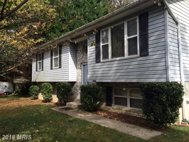
Homes Near Base